Where can you paddle?
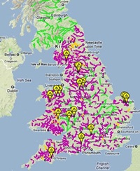
Actually, not that many places but is does change on a yearly basis. Click on the map to investigate the access situation in England, Scotland & Wales. This will take you to an an interactive map of UK rivers, setup and maintained by volunteers to monitor the changing access situation. It also details access incidents where paddlers have been challenged for paddling a river. If you have any current information or incidents to report on local rivers, please submit it using the “report an incident” link in the white box that appears when you click on a river. This site relies on feedback from actual paddlers. The “relevant links” page is packed with useful background on the fight for access over the years.
Landowners, Angling Associations and even the government are promoting Voluntary Access Agreements (VAAs) as a solution to the poor access situation. These have failed to deliver improvements over the last 30 years and are often mechanisms to prevent paddlers using rivers rather than to encourage them.
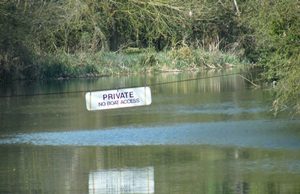
A local example of a VAA is the river Blackwater in Essex. Local landowners have agreed to “allow” access to “their” river on one day per year, with a maximum of 50 paddlers and only via a single organisation and at a cost. This has been agreed to by the BCU local access officer – this following extract is from the Essex Canoe Association website:
These so called “agreements” are repeated all over the country and it is important to try where you can to make sure permissions have been granted.
Your SCC membership is affiliated to British Canoeing and this covers your river license for the River Stour but if you go away on holiday and paddle other rivers as a private paddler (or want to paddle other rivers outside the club) you need to consider taking out a British Canoeing membership because this has a wider remit or more rivers. More information can be found about this and other benefits here: https://www.britishcanoeing.org.uk